It is easy to underestimate just how much the people who lived in and around Heywood during centuries past relied on local sources of necessities such as coal, water, stone, sand, bricks, clay and gravel. Local dairy farms provided milk, and the various woodlands and open countryside also provided timber and game.
Before the 19th century, and especially the development of train and canal networks, the notion of having bricks, coal and similar items transported over large distances was impractical, especially when the local landscape was dotted with dozens of quarries, sand pits, and over 200 small mine shafts and adits. There were also over a hundred small wells that provided water to the residents.
These sites are depicted on the map below (specially made for this website and based on historical mapping). Many smaller resource sites would not have been shown on those old maps, so this has to be taken as probably incomplete. The map is best viewed in full screen (left-click the 'square' icon in top right corner of the title bar).
It is interesting to track the existence of these sites over time on 19th-century maps. The first Ordnance Survey maps were developed during the late 1840s, and the attention to detail is quite incredible. They depict an abundance of local wells, quarries, coal pits, etc. Some of these dated from before the Industrial Revolution gained pace in the late 18th century, when the local population still mostly lived in scattered folds, which were quite self-reliant with their own coal pits and water sources. The area was rapidly developing into an urban landscape in the 1840s, and some pits and quarries were already labelled as 'old', having been depleted before that time. Many others fell into disuse over the following decades as they too were depleted, or new transport routes enabled materials to be transported from outside the local region. When the next Ordnance Survey maps were created in the 1890s, they showed far fewer local resource sites.
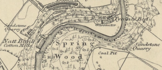 |
| This extract from the Ordnance Survey map published in 1851 shows how various resources sites were labelled on the maps. |
Wells had been particularly crucial utilities in a time before piped water. They were made by digging or drilling a hole to reach underground aquifers. The water was then drawn up using either a pump or bucket. It wasn't until around the mid-19th century that (a few) houses began to be connected to a piped water system, and the use of communal wells remained widespread. The circular shafts of the wells were usually a minimum one metre in diameter, were lined with brickwork, and most were no deeper than 10 metres, which was the maximum depth at which a common iron suction pump could function.
An old resident recalled the 'Owd Lone pump' that was located at Longfield (a large area behind St James' Church) in the 1840s:
'Old Billy Wolstenholme looked after the pump, and every family that used it paid twopence per week for the water. Grand water, fresh from the sand hill. No fun now, helping the girls to carry the water home. Longfield then was a far different place from now.’ (Heywood Advertiser, 5 January 1905).
By the 20th century, when indoor plumbing systems were commonplace, the wells and pumps became a thing of the past.
Local coal mining 'officially' started in 1580 when Elizabeth I granted John Blackwall the right to mine coal in the Cheesden Valley. Some landlords around this time allowed their tenants to dig coal for domestic use, and during the 17th century the small communities known as ‘folds’ were allowed to have their own mines, and the valleys around Heywood were dotted with small pits. Early miners dug for coal seams lying close to the surface, but another method was to cut sloping or horizontal tunnels into hillsides and drag the coal out in baskets. Deeper shafts were dug with the onset of increased industrialisation.
There were many other types of pits dug in the land around the Heywood area, including over 20 sand pits. The sand excavated from these would have been used from early times as the main ingredient in making mortar for building work. It was also useful for making moulds for cast iron in foundries. Another use was in glass production, and during the mid-19th-century Abraham Simcock had a glass-blowing workshop in two cottages at Crimble, not far from two sand pits there. Gravel was similarly dug from pits, and this material was used for mending local roads and also in the building trade.
 |
| Sand pits near Roe Acre (1851 Ordnance Survey map). |
Clay pits provided material for earthenware, and there was a pottery near some local clay pits at Jericho, on Bury Old Road, during the 1840s. Robert Diggle started a clay-pipe making business in this location in the mid-19th century. Clay was also used for bricks, and Heywood had a number of 'brickfields' in the earlier 19th century. Traditionally, the topsoil was removed from these fields and the clay beneath was stripped and mixed with chalk and ash to make the bricks.
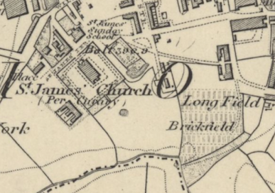 |
| A brickfield near St James' Church (1851 Ordnance Survey map). |
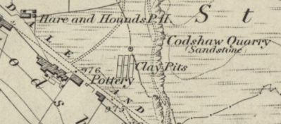 |
| A pottery next to clay pits near the top of what is now Ashworth Road. This pottery was still in existence in the 1890s (1851 Ordnance Survey map). |
Stone was quarried from the local landscape for several centuries, and before the 19th century this would have been on a small scale and taking place close to where the stone was needed. For example, farmers who wanted material for buildings or drystone walls would take stone from nearby outcrops. Early quarrymen seeking stone to sell would also use such outcrops. Ordnance Survey maps drawn up in the 1840s show dozens of these small quarries based in outcrops high on the valley sides or near the edge of moorland around Heywood. The stone would probably have been shaped close to the quarry, thereby reducing weight for the horse-drawn cart journey to where it was needed.
Coal gas was a locally-generated energy resource. Before the mid-20th century, the gas was produced in retorts
by heating coal in the absence of air, and stored in large metal tanks known as gasometers. The gas was then distributed through pipes. The first public piped gas supply was installed in London in 1807, to gas lamps along the length of Pall Mall. The Heywood Gas Company was formed in 1848 and was based at Hooley Bridge where a number of gasometers were situated. A larger modern gasometer survived by the riverside near there until the late 20th century.
The remains of some of those old resource sites can still be seen today, but most are long gone. The most profound man-made impact on the landscape is also the most ancient, as the West Pennine Moors were created when the forest that once covered them was gradually cleared, first by settlers during the Neolithic and Bronze Ages, and then the Anglo-Saxons and Vikings. Pockets of woodland survive along the valleys today, but these once extended much further.
Modern impacts were more subtle. Remaining coal pits were capped, and clay, sand or gravel pits and old brickfields disappeared, with some of the land being swallowed by urban expansion. Dormant quarries became cliffs or grassy indentations or craters in hillsides, sometimes with ponds forming in the base. The images (below) of Castle Hill Quarry at Birtle, which was in use by the 1840s, show its lingering impact on the landscape (a video of the site
can be viewed here).
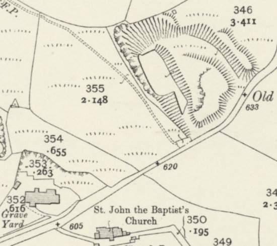 |
| The quarry in 1908 (Ordnance Survey map 1910). |
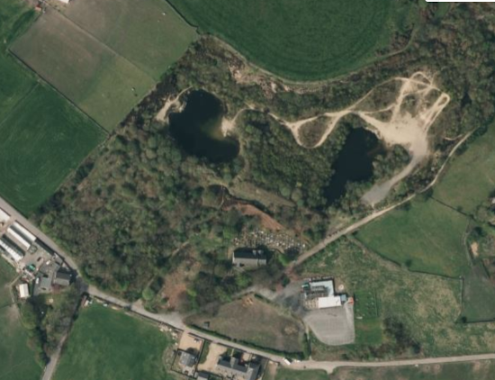 |
| Modern aerial shot (Microsoft Bing). |
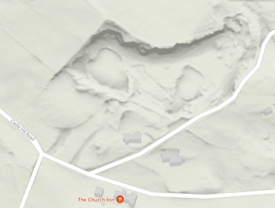 |
| Modern aerial shot showing topography (Microsoft Bing). |
Some street also names offer clues to former use, such as Gas Street, Sandy Lane and Mine Street (formerly Coal Pit Lane). Clay Lane and adjoining Full Pot Lane suggest the early presence of clay pits that were not marked on any maps. Sandpits Farm near Hopwood once contained large sand pits, and during the 19th century there was a Wellmeadow Mill on the site that later housed Times Mill.
'Long before the advent of the Heywood Water Works, Heywood must have been fairly well supplied with springs and wells. For proof of this we have only to notice the variety of local names such as Spring Brow, Spring Cottage, Spring Gardens, Springfield, Pump (Hopwood), Longfield Pump, and many others. There used to be a considerable spring situated in what was known as 'Jim Ogden Hollow' (Greentown), and there was also a good spring near James-street.' (Heywood Advertiser, 26 May 1905)
(Greentown was in the vicinity of Miller Street. The 'Pump' area of Hopwood could well have been off the end of what is now Gregge Street, which had four pumps marked there on the 1851 map.)
Our modern resource needs have obviously changed, and we live in an age of convenience when we don't need to extract basic resources from the land around Heywood. This aspect of history is often overlooked now, but if you know where to look, there are reminders of what was an important and hard part of life for our ancestors.


Comments