The Bridges of Heywood
This page is updated as new information comes to hand. Any further information that readers can provide on this subject is always welcome.
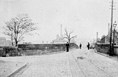
Heap Bridge: 1884
 |
| Heap Bridge, circa 1910. |
The current bridge dates from 1884, but there would have been a bridge at this spot centuries earlier. The waters are quite shallow here, which in pre-bridge days would have made it a convenient place to cross the river and provide a route to and from Bury from the south-east.
Queen's Park Bridge: 1933
Prior to the construction of this large bridge, the road (then known as William Street) only ran as far as the park gates. The name was changed to Queen's Park Road with the opening of the bridge.
Hooley Bridge: ??
Queen's Park Bridge: 1933
 |
| Queen's Park Road over the bridge. |
Prior to the construction of this large bridge, the road (then known as William Street) only ran as far as the park gates. The name was changed to Queen's Park Road with the opening of the bridge.
Hooley Bridge: ??
 |
| Hooley Bridge. |
This would have been an important north-south route in early centuries, which probably first developed here because the water at this spot is quite shallow and would have been crossable prior to a bridge being built. There are references to a bridge here during the 17th century, but the current bridge appears to be a late-mid 19th-century type.
Bottom o'th' Brow Bridge: 1900s

Comments
I was recently browsing your blog entries from this year and found your entry about bridges of Heywood.
I do a google search once in a while for places where a couple of my families lived in the Heywood area. Last year I came across a nice archaeological report for the site of Hooley Bridge Mills.
Perhaps you have already seen it, but in case you have not, here’s the link to a pdf of the report.
https://library.thehumanjourney.net/1583/1/Full%20Report%20070409.pdf
On pg. 20 of the pdf, p. 8 of the report, the author stated:
“Hooley Bridge Mills, and the industrial village that surrounded the mills, took their name
from the bridge over the river Roch that had been built by the time that Yate’s
map was produced in 1786.”
A small section of the Yates map is included in the report. The Yates map provides a date of at least 1786 for the bridge, assuming it is the exact same structure.
Perhaps there is an archaeological report or something similar for the bridge itself buried in a local archive somewhere?
I enjoy looking in on your Heywood blog once in a while & especially enjoy reading about the local history of the area. Well done, blog on!
C. Etter
Thank you for all the work you are putting in I really admire how you put all our local information together, mine is on hundreds of pieces of paper and word doc files. Thank you.