The Old Mills of Heywood: A-B
 |
| Bamford Woollen Mills. |
 |
| You can also find information about the following mills on this interactive map (link). |
Adelaide Mills
Cotton
Adelaide Street/Queen’s Park Road
1888 directory: Eastwood Abraham, cotton waste dealer (in this location).
1891: Building present on Ordnance Survey map, but not labelled.
1957: Named on Ordnance Survey map as Adelaide Mills (cotton).
1969: Building not present on Ordnance Survey map.
 |
| Adelaide Mills, OS map, 1957. |
Albert Mill
Cotton spinning
Green Lane, Hopwood
1848: Not present on Ordnance Survey map.
Owned by Thomas Radcliffe and Charles Newhouse, colloquially known as ‘Charlie’s Mill’.
1869: Sold to Barlow and Jones.
1880 directory: Jones, Son & Faulkner, cotton spinners, Schofield Street and Albert Mills.
1888 directory: Hoyle Richard & Co. Albert Mill, Green la. Hopwood.
1891 directory: Richard Hoyle and Co, 19,934 spindles, 248/508.
1922 directory: D. Healey and Sons here.
1937: Marked on Ordnance Survey map as ‘disused’.
1957: Marked on Ordnance Survey map as ‘furniture’.
1986: Still on Ordnance Survey map
2018: Building no longer present.
 |
| Albert Mill, OS map, 1928. |
Albert New Mill
Cotton spinning
Green Lane, Hopwood
1848: Not present on Ordnance Survey map.
1869: Charles Newhouse, former owner of Albert Mill, became the owner.
1888: Albert New Mill Co. Limited, Albert New Mill, Green la. Hopwood (cotton spinners).
1891: Albert New Mill Co, Limited, 26,000 spindles, 188/328 water twist, 248/348 cop twist.
1922: D. Healey and Sons.
1937: Marked on Ordnance Survey map as ‘disused’.
1947: Present on Ordnance Survey map.
1957: Not present on Ordnance Survey map.
 |
| Albert New Mill, OS map, 1928. |
Albion Mill
Cotton spinning
Sefton Street, across from Sun Iron Foundry.
1871 directory: Pearson and Newhouse, Albion mill (cotton spinners).
1880 directory: Pearson William, cotton spinner, Albion Mill; h. Birch house, Hopwood.
1891 directory: William Pearson, 12,000 spindles, 128/401, pin cops, 168/328 twist.
1891: Named on Ordnance Survey map as Albion Mill (cotton).
1968: Building present on Ordnance Survey map.
1988: Building not present on Ordnance Survey map.
 |
| Albion Mill, OS map, 1890. |
Ashworth Fulling Mill
Woollen
Naden Brook, Clay Lane
1808: Edmund Ashworth listed as the fuller here.
1848: Named as Ashworth Mill (fulling) on Ordnance Survey map.
1890: Mill marked on Ordnance Survey map.
1908: Marked on Ordnance Survey map as Ashworth Mill (disused).
1956: Marked on Ordnance Survey map as Ashworth Mill (disused).
2018: Ruins of mill still present.
 |
| Ashworth Fulling Mill, OS map, 1848. |
Ashworth Mill (cotton)
Cotton
Naden Brook, Clay Lane
1848: Named on Ordnance Survey map as Ashworth Mill (woollen and cotton).
1890: Building not present on Ordnance Survey map.
 |
| Ashworth Mill (woollen and cotton), OS map 1848. |
Atlantic Mill
Cotton
Cross Street
1847: Not present on Ordnance Survey map.
1890: Marked on Ordnance Survey map as Cotton Mills.
1922 directory: Howe & Coates here.
1957: Named on Ordnance Survey map as Atlantic Mill.
1977: Building expansion shown on Ordnance Survey map.
1986: Marked on Ordnance Survey map as ‘depot works’, in a new building.
 |
| Atlantic Mill, OS map, 1956. |
Baitings Mill
Cotton
Edenfield Road, Norden, Rochdale
1848: Marked on Ordnance Survey map as Baitings Mill (cotton).
1890: Marked on Ordnance Survey map as Baitings Mill (cotton).
1908: Marked on Ordnance Survey map as Baitings Mill (fustian).
1923: Marked on Ordnance Survey map as Baitings Mill (fustian).
1961: Marked on Ordnance Survey map as Mill.
1986: Mill was known as Cudsworth's Mill and made cotton fustian cloth for corduroy material.
The building was demolished after 2000, and by 2003 there was a housing development here.
 |
| Baitings Mill, OS map, 1891. |
Bamford Woollen Mills
Woollen
Norden Road, Birtle-cum-Bamford
1847: Not present on Ordnance Survey map.
1890: Marked on Ordnance Survey map as Bamford Woollen Mills.
1880: Porritt Samuel & Sons, woollen manufacturers, Bamford Mills and Meadowcroft Mill.
1891: Samuel Porritt and Sons (and fullers and finishers), Bamford, woollen and Meadowcroft Mills; 160 looms, blanketings, tapes, roller cloths, &c.
1982: Demolished.
 |
| Bamford Woollen Mills, OS map, 1890. |
Belgrave Shuttle Works
Shuttle manufacturing
Belgrave Street, Broadfield
1830: Established by Booth Brothers, shuttle manufacturers.
1908: Sold out to Pilkington Ltd.
1920s: Pilkingtons moved to Highfield Mill, Springfield Street, where they still made shuttles and also operated 800 looms.
2018: Building still partially present and in use.
 |
| Belgrave Works, OS map, 1928. |
Birch Mills
Cotton spinning
Manchester Road, Birch
1848: Marked on Ordnance Survey map as Cotton Mill.
1891 directory: W.C. Wood and Brothers, Heywood and Birch Mills; 1,306 looms; Manchester office-25, Portland street.
1940s: Used by Salford Electronic Instruments.
1956: Marked on Ordnance Survey map as Birch Mills (cotton).
2018: Building still present and in use.
Birtle Moor
1847: Small building marked here as Ned Mill. Has also been referred to 'Owd Ned's Mill' and Elbut Lane Mill.
1891 directory: Oliver Ormrod, Birtle Bleach Works.
1894: Larger buildings marked on Ordnance Survey map as Birtle Bleach Works.
1956: Marked on Ordnance Survey map as Birtle Bleach Works.
2018: Some buildings still present, converted to residences circa 2010.
 |
| Birtle Bleach Works, OS map, 1890. |
Birtle Dene Mill
Cotton spinning and weaving
Cheesden Brook, Birtle
1824: Built for Thomas Ramsbottom. This was a full-scale 4-storey cotton spinning mill and weaving shed. The mill produced its own gas and was powered by a large waterwheel and auxiliary engine. There were also three rows of cottages built for the workers.
1890: Taken over by Goulden, Adams and Company.
1894: Closed.
2018: Building no longer present.
 |
| Birtle Dene Mill, OS map, 1847. |
Black Pits Mill
Cotton
Naden Brook
1847: Marked on Ordnance Survey map as Black Pits Mill (cotton mill).
1891 Directory: Blackpits Cotton Spinning and Manufacturing Co Limited; 15,670 spindles, 1811/361, twist; 474 looms, fustians.
1928: Marked on Ordnance Survey map as Black Pits Mill (cotton).
1938: Marked on Ordnance Survey map as Black Pits Mill.
1955: Not present on Ordnance Survey map.
2016: Black Pits Mill chimney restored.
 |
| Black Pits Mill, OS Map, 1847. |
Bowling Green Mill
Cotton spinning and manufacturing
Church Street
1829 directory: Cleggs and Halls.
1850 directory: Cleggs and Halls, Bowling green Mill, and 1 Sussex street, Manchester (cotton spinner and manufacturer).
1871 directory: Berry George H. & Co., Bowling Green mill (cotton spinners).
1880 directory: Berry George Henry & Co., cotton spinners and manufacturers, William Street and Bowling Green Mills.
1891: Named on Ordnance Survey map as Bowling Green Mill (cotton).
1907: Building not present on Ordnance Survey Map.
 |
| Bowling Green Mill, OS map 1848. |
Bridge Hall Dye Works
Dye
Heap Bridge
1891: Buildings not present on Ordnance Survey map.
1908: Marked on Ordnance Survey map as Dye Works.
1928: Marked on Ordnance Survey map as Bridge Hall Dye Works.
2018: Buildings still present?
 |
| Bridge Hall Dye Works, OS map, 1928. |
Bridge Hall Paper Mill
Paper
River Roch, Heap Bridge
1716: George Warburton was running a paper-making operation at Bridge Hall Mills by this time.
1776: Mills were being run by Thomas Crompton.
1810: ‘Owd Jimmy’ Wrigley took over the mills after the death of Crompton.
1829 directory: T. Blomley, Bridge Hall Mill.
1848: Marked on Ordnance Survey map as Bridge Hall Paper Mill.
1880: Lancashire & Yorkshire Railway Co. to open a freight-only branch line to the paper mills by this time.
1915: Roof collapse killed nine workers.
1924: Wrigley’s company went into voluntary liquidation.
1928: Transparent Paper Ltd renovated the mill and commenced cellulose film production.
1940s: Used for production of jettison fuel tanks during WW2.
1980: Transparent Paper closed. Premises were later home to Tetrosyl Ltd and Printpack Europe Ltd.
2018: Buildings still present and in use.
Bridge Hall Woollen Mill
Woollen
River Roch, Heap Bridge
1848: Marked on Ordnance Survey map as Bridge Hall Woollen Mill.
1890: Marked on Ordnance Survey map as Bridge Hall Mill (disused).
1908: Building not present on Ordnance Survey map.
Bridge Mill
Cotton spinning
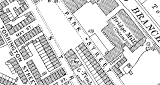
Park Street
1847: Not present on Ordnance Survey map.
1871 directory: Tattersall R. J. and E., Bridge mill, Hopwood (cotton spinners).
1880 directory: Tattersall R. J. & E., cotton spinners, Bridge Mill, Hopwood.
1891 directory: Edward Tattersall; 30,000 spindles, 508/608 weft, 408/468 twist.
1922 directory: Operated by Tattersall, E Ltd.
1937: Marked as Cotton Mill on Ordnance Survey map.
1947: Not present on Ordnance Survey map.
1915: Roof collapse killed nine workers.
1924: Wrigley’s company went into voluntary liquidation.
1928: Transparent Paper Ltd renovated the mill and commenced cellulose film production.
1940s: Used for production of jettison fuel tanks during WW2.
1980: Transparent Paper closed. Premises were later home to Tetrosyl Ltd and Printpack Europe Ltd.
2018: Buildings still present and in use.
 |
| Bridge Hall Paper Mills, OS map, 1928. |
Bridge Hall Woollen Mill
Woollen
River Roch, Heap Bridge
1848: Marked on Ordnance Survey map as Bridge Hall Woollen Mill.
1890: Marked on Ordnance Survey map as Bridge Hall Mill (disused).
1908: Building not present on Ordnance Survey map.
 |
| Bridge Hall Woollen Mills, OS map, 1847. |
Bridge Mill
Cotton spinning
Park Street
1847: Not present on Ordnance Survey map.
1871 directory: Tattersall R. J. and E., Bridge mill, Hopwood (cotton spinners).
1880 directory: Tattersall R. J. & E., cotton spinners, Bridge Mill, Hopwood.
1891 directory: Edward Tattersall; 30,000 spindles, 508/608 weft, 408/468 twist.
1922 directory: Operated by Tattersall, E Ltd.
1937: Marked as Cotton Mill on Ordnance Survey map.
1947: Not present on Ordnance Survey map.
Bridge Mill (aka Cheesden Bar)
Cotton and woollen, later waste twills and calicos
Edenfield Road, Cheesden
1840: Open by this time. This was a two-storey mill, at one point being used for woollen manufacture upstairs and cotton spinning downstairs. It was later used for waste twills and calicos.
1891 directory: John Kay, Cheesden Bar Mill; 840 spindles, 48/88 weft; 25 looms, waste twills and waste calicoes.
1898: Closed after the water rights were sold for the construction of the nearby Ashworth Reservoir.
 |
| Bridge Mill (Cheesden Bar), OS map, 1848. |
Britannia Mill - see Wrigley Brook Mill
Broad Oak Mill
Woollen
River Roch, Fairfield, Bury
1818: Marked on Greenwood's 1818 map.
1841 directory: Porter James, fulling miller, Broadoak mill.
1848: Marked on Ordnance Survey map.
1908: Marked on Ordnance Survey map as ‘disused’.
1928: Building not present on Ordnance Survey map.
Broadfield Mill
Rope, also cotton spinning
Pilsworth Road, Broadfield
1880 directory: Diggle Bros., joiners and builders, Bamford Road; and cotton spinners, Broadfield Mill.
1888 directory: Healey Brothers (manufacturers of all kinds of rope, twine, cotton & tubular banding; also main driving ropes for mills), Cartridge Steam Ropery & Broadfield Mill.
1891 directory: Wilton Spinning Co, Limited, 12,280 spindles, 348/548 weft.
1932 directory: JW and R Healey & Co. move to the mill (from Clegg’s Boiler Works, Wham).
2018: Building no longer present.
Woollen
River Roch, Bamford
1848: Marked on Ordnance Survey map as Broadhalgh Fulling Mill.
1891 directory: John Ashworth, Broadhalgh Mill (fuller and finisher).
1949: Weir washed away in storm around this time.
1957: Marked on Ordnance Survey map as Broadhalgh Mill (woollen).
1971: Production stopped around this time. Sold to Frank Worrall in 1977, who demolished it.
Brook Mills
Cotton spinning and manufacturing
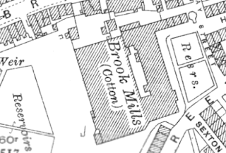
Bridge Street
1841 directory: Kay John Hilton & Son, cotton spinners and manufacturer, Bridge St.
1851: Marked on Ordnance Survey map as Bridge Street Mills.
1888 directory: Brook Mills Co. Limited, Bridge St. (cotton spinners).
1891 directory: Brook Mills Co, Ltd., Brook and Springfield Mills; 25,000 spindles; 500 looms, plains, twills, jeanettes, &c.
1922 directory: Pearson & Morten.
1957: Marked on Ordnance Survey map as Cotton Mill.
1962: Demolished.
Woollen
River Roch, Fairfield, Bury
1818: Marked on Greenwood's 1818 map.
1841 directory: Porter James, fulling miller, Broadoak mill.
1848: Marked on Ordnance Survey map.
1908: Marked on Ordnance Survey map as ‘disused’.
1928: Building not present on Ordnance Survey map.
 |
| Broad Oak Mill, OS map, 1848. |
Broadfield Mill
Rope, also cotton spinning
Pilsworth Road, Broadfield
1880 directory: Diggle Bros., joiners and builders, Bamford Road; and cotton spinners, Broadfield Mill.
1888 directory: Healey Brothers (manufacturers of all kinds of rope, twine, cotton & tubular banding; also main driving ropes for mills), Cartridge Steam Ropery & Broadfield Mill.
1891 directory: Wilton Spinning Co, Limited, 12,280 spindles, 348/548 weft.
1932 directory: JW and R Healey & Co. move to the mill (from Clegg’s Boiler Works, Wham).
2018: Building no longer present.
 |
| Broadfield Mill, OS map, 1937. |
Woollen
River Roch, Bamford
1848: Marked on Ordnance Survey map as Broadhalgh Fulling Mill.
1891 directory: John Ashworth, Broadhalgh Mill (fuller and finisher).
1949: Weir washed away in storm around this time.
1957: Marked on Ordnance Survey map as Broadhalgh Mill (woollen).
1971: Production stopped around this time. Sold to Frank Worrall in 1977, who demolished it.
 |
| Broadhalgh Mill, OS map, 1891. |
Brook Mills
Cotton spinning and manufacturing
Bridge Street
1841 directory: Kay John Hilton & Son, cotton spinners and manufacturer, Bridge St.
1851: Marked on Ordnance Survey map as Bridge Street Mills.
1888 directory: Brook Mills Co. Limited, Bridge St. (cotton spinners).
1891 directory: Brook Mills Co, Ltd., Brook and Springfield Mills; 25,000 spindles; 500 looms, plains, twills, jeanettes, &c.
1922 directory: Pearson & Morten.
1957: Marked on Ordnance Survey map as Cotton Mill.
1962: Demolished.
References
- Barrett’s 1880 Directory of Bury, Heywood, Ramsbottom, Radcliffe and Pilkington.
- Commercial Directory and Shippers Guide, 1875.
- Hannah Haynes, Heywood, Chalford Publishing, 1997.
- Heap’s 1850 Directory of Bury
- Heywood Advertiser (various dates).
- Heywood Living Memories.
- John Hudson, Heywood in Old Photographs, Sutton Publishing 1994.
- Ordnance Survey maps (various).
- Pigot and Co.’s national commercial directory for 1828-29.
- Pigot and Co.’s Royal National and Commercial Directory of August 1841.
- AV Sandiford and TE Ashworth, The Forgotten Valley, Bury and District Local History Society, 1981.
- Slater’s 1888 Directory of Bury, Heywood, Radcliffe and Ramsbottom.
- Worrall’s 1871 Directory of Bury, Bolton and district.
- Worrall's Cotton Spinners & Manufacturers Directory for Lancashire 1891.
- Worrall’s 1891 Directory of Bury, Bolton and district.


Comments