The Old Mills of Heywood: F-H
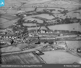
| Mills at Heap Bridge, 1927. (britainfromabove.org.uk) |
 |
| You can also find information about the following mills on this interactive map. |
Fold Mill
Cotton spinning and manufacturingMarket Street
1829 directory: Gorton, Clegg and Co.
1829 directory: James Clegg.
1841 directory: Clegg James, cotton spinner & manufacturer, Fold mill.
1850 directory: Clegg James, Fold mill, and 4 Sussex street and 10 New Market lane, Manchester (cotton spinner and manufacturer).
1851: Marked on OS map as Fold Mill.
1880 directory: Fold Mill Spinning Co., Limited, cotton spinners, Market Street; James Meadowcroft, manager.
1890: Building not present on OS map.
 |
| Fold Mill (centre), OS map, 1847. |
Foundry Street Mill
Cotton spinning, also cotton waste dealers, and foundry at times
Foundry Street
1847: Marked on OS map as Moss Foundry.
1850 directory: Mills David, Foundry Mill, Dawson street (cotton spinners).
1871 directory: Radcliffe and Mills, Foundry street mills (cotton spinners).
1880: Isherwood Thomas, cotton spinner, Foundry Street Mill, and cotton waste dealer, Ormrod Street; h. Springfield house, Hopwood.
1891 directory: Thomas Isherwood, Foundry Street and Railway Street Mills; 17,000 spindles, 68/248.
1922 directory: Operated by Isherwood, T.
1928: Marked on OS map as Cotton Mill.
1938: Building not present on OS map.
 |
| Foundry Street Mill, OS map, 1928. |
Fountain Mill - see Stanley Mill
Four Acre Mill
Cotton
Cheesden Brook, Cheesden Pasture
1810: Built as the highest cotton mill on Cheesden Brook for local farmer John Howarth. Four Acre had a waterwheel 4-feet wide and 36 feet in diameter.
1893: Closed by this time.
1982: Archaeology - Remains of stone building with waterwheel pit, pond and race, and coal workings.
 |
| Four Acre Mill, OS map, 1848. |
Garrison Mill
Cotton
Pilsworth Road, Broadfield
1848: Not present on OS map.
1890: Present on OS map.
1928: Building expansion shown on OS map.
1957: Marked on OS map as Cotton Mill.
2018: Building still present.
 |
| Garrison Mill, OS map, 1929. |
Globe Mill (later Sefton Mill)
Cotton spinning and manufacturing
Green Lane, Hopwood
1847: Not present on OS map.
1875 directory: Castleton Cotton Spinning and Manufacturing Co., Globe mill, Heywood.
1880 directory: Castleton Cotton Spinning & Manufacturing Co., Limited, Globe Mill, Green lane; B. Clarkson, manager; William Ashworth, secretary.
1891 directory: Castleton Cotton Spinning and Manufacturing Co, Limited, 20,000 spindles, 368 weft, 21, twist; 496 looms, grey cloth.
1910: Named on OS map as Sefton Mill.
1939 map: Marked on OS map as ‘disused’.
1947: Named on revised OS map but no buildings are marked. Demolished by this time.
 |
| Sefton Mill, OS map, 1928. |
Gooden Lane Mill (later Gooden Lane Rope Works)
Cotton spinning, later ropery
Schofield Street
1848: Marked on OS map as Cotton Mill.
1871 directory: Mayall Samuel, Dawson hill and Gooden lane mills (cotton spinners).
1888 directory: Mayall Alfred T. Gooden Lane Mills (cotton spinners).
1890: Marked on OS map as Mill.
1907: Marked on OS map as Cotton Mill, also has rope walk.
1928: Marked on OS map as Cotton Mill.
1920s?: Healey, J W & R. established Star Ropery here.
1957: Marked on OS map as Gooden Lane Rope Works.
1969: Marked on OS map as Gooden Lane Rope Works.
2018: Building still present.
 |
| Gooden Lane Mills, OS map, 1927. |
Gooden Mill (later Burns Mill)
Cotton spinning and manufacturing
Manchester Street
1841 directory: Wild John, cotton spinner & manufacturer, Manchester St.
1848: Named on OS map as Gooden Mill (cotton).
1850 directory: Wild John & Son, Gooden Mills, Manchester street (cotton spinners and manufacturers).
1875 directory: Weston Samuel, Gooden mills, Heywood.
1880 directory: Gooden Mills Spinning Co., Limited; James Taylor, manager.
1891: Named on OS map as Gooden Mills (disused).
1891: Gooden Mill name not in Worrall’s Directory.
1891: Burns Mill established at this site with 51,584 ring spindles.
1938: Building offered for sale on condition the spindles were sold and the mill was not used for cotton.
1940s: Used by Salford Electronic Instruments.
1957: Marked on OS map as ‘disinfectant works’.
1977: Still marked on OS map as ‘disinfectant works’.
1986: Still present on OS map.
2018: No longer present.
 |
| Burns Mill, OS map, 1907. |
Gorton's Ropery
Rope
Dewhurst Street
1851: Not present on OS map.
1888 directory: Gorton, Richard, rope & twine manufacturer.
1891: Building present but unnamed on OS map. There is a ropewalk directly across the road.
1907: Building not present on OS map, and the ropewalk area is now a row of houses (Tonge Street).
Gorton's Ropery, OS map, 1891.
|
Green Booth Mills
Woollen
Green Booth village
1840s: Weaving mill built for James Butterworth of Norden, specialising in the production of woollen flannel. Coal for the mill came from the nearby East Knowl colliery.
1848: Marked on OS map as Green Booth Mills (woollen).
1891 directory: James Butterworth and Son (flannels, &c.--and fullers and finishers), Greenbooth Mills,
1911: The mill - by then managed by Butterworth’s grandsons - went bankrupt.
1923: Marked on OS maps as Greenbooth Mill (disused).
1938: Buildings no longer present on OS map.
1963: The deserted village and buildings were submerged by a new reservoir for the Heywood and Middleton Water Board.
 |
| Green Booth Mills, OS map, 1848. |
Gregge Street Mill
Cotton spinning and manufacturing
Gregge Street
1847: Not present on OS map.
1871 directory: Tattersall James, Victoria and Gregge street mills, Pitfield mills, Bamford, and 27a, Fountain street, Manchester (cotton spinners).
1880 directory: Tattersall James & Sons, cotton spinners and manufacturers, Victoria and Gregge Street Mills, Hopwood.
1891 directory: Phoenix Mills, Tattersall James and Sons, Limited, Victoria and Gregge Street Mills; 38,000 spindles, 169/448 weft, 128/288 warp ; and at Pitfield Mills, Bamford; Manchester office-14, Brown street.
1928: Marked on OS map as Cotton Mill.
1937: Marked as ‘disused’ on OS map.
1957: Marked on OS map as chemical works.
1986: Still present on OS map.
2018: Building not present.
 |
| Gregge Street Mill, OS map, 1907. |
Heady Hill Dye Works (was possibly also the Heady Hill Mill [cotton])
Dye
Union Street, Heady Hill
1847: Buildings on OS map here marked as Methodist Association School. Heady Hill
1850: Todd William and Co., Heady hill Mill (cotton spinners and manufacturers). There is no mill in this area on the 1847 OS map, and the only mill on the 1890 map is the Dye Works, so it is possible that the cotton mill preceded the dyeing mill here.
1880: Todd William, Jun., oil and tallow refiner, wheel grease, and boiler composition manufacturer, Heady Hill Mill.
1890: Marked on OS map as Dye Works.
1937: Marked on OS map as Dye Works. Run by Smethursts.
1956: Building not present on OS map. Housing development took place in this area during this decade.
 |
| Heady Hill Dye Works, OS map, 1937. |
Heap Bridge Woollen Mills
Woollen
Heap Bridge
1848: Buildings not present on OS map.
1888 directory: Ainsworth Thomas & Co. woollen manufacturers, Heap Bridge Mills.
1890: Marked on OS map as Heap Bridge Mills (woollen).
1908: Marked on OS map as Heap Bridge Mills (woollen). Site includes a dye works.
1928: Marked on OS map as Heap Bridge Mills (woollen).
2000: Buildings still present.
 |
| Heap Bridge Woollen Mills, OS map, 1928. |
Heap Bridge Paper Mills
Paper
Bury New Road, Heap Bridge
1817: Run by the Grundy family, who owned the nearby Bridge Hall estate.
1880 directory: Wrigley E. Grundy & Co., woollen manufacturers, Heap Bridge Mills; warehouse, 8 Mosley buildings, Manchester.
1880: Mill closed.
1882: Yates Duxbury & Son Ltd took over the insolvent Heap Bridge Paper Co.
1887: Became the first mill in Lancashire with electric lighting.
1890: Marked on OS map as Paper Mill.
1928: Now two mills, with Heap Bridge Paper Mill No.2 located across the road.
1988: Buildings still present on OS map.
2018: Buildings no longer present.
 |
| Heap Bridge Paper Mills, OS map, 1928. |
Heap Brow Mill
Cotton
Unknown
There was a cotton mill in Heap Brow during the early 19th century but it is uncertain where it actually was. It is possible that it was in the building on Bury New Road that was taken over by Grundy in 1817 for the Heap Bridge Paper Mill. The following snippets appeared in the Heywood Advertiser during 1907-08:
‘Thomas Greenhalgh went into partnership with Mr James Kay, to a little cotton mill near Heap Brow, that belonged to the Kay family. The concern at Heap Brow went on very well, and they bought cotton and sold their weft either in Bolton or in the Manchester markets… New inventions in machinery rapidly increased about this town, and the late Sir Robert Peel was the great cotton fugleman for them all. Greenhalgh's and Kay's machinery at Heap Brow became of little value; as all the little cotton mills about Bury were quickly progressing it was mutually agreed that their partnership should be dissolved. What money they accumulated here I am unable to say, but the Kay family built a large factory at Heywood.’
‘The James Kay with whom Thomas Greenhalgh went into partnership at "a little cotton mill near Heap Brow," as recorded in No. 283 of "Heywood Notes and Queries," will be identical with the "James Kay, of Heap, cotton spinner," who died in the early part of 1814, leaving John Hilton Kay as his sole executor.’
Heap Workhouse
Bury Old Road, Heady Hill
A workhouse was a 19th-century institution where those unable to support themselves were offered accommodation and employment.
1834: The workhouse at Heady Hill was controlled by Bury township until this time.
1837: Bury Poor Law Union was formed, managing various workhouses including Heady Hill, which appears to have been used for only females around this time.
1841 directory: Workhouse, Bury Old road - George Lord, master; Elizabeth Lord, mistress.
1848: The buildings are unnamed but shown on Union Street on the OS map, with two adjacent schools.
1850: Lord Derby refused to renew the lease for workhouses on his land, including Heap.
1850 directory: Poor Law Union. Workhouse, Bury old road - Geo. Lord, master; Elizh. Lord, matron. Guardians - Hilton Kay, Thomas Holden, and John Lord. Medical officer - James Taylor, York street. Relieving Officer - Richard Eubank, 16 Market street. Towns's Office, 3 Dawson street.
1857: A new workhouse opened at Jericho, Bury, replacing several smaller ones, including Heady Hill.
1890: Buildings are present in this location on the OS map but appear to be rows of houses, including the Royal George pub.
1950s: This area was redeveloped with new housing.
 |
| Workhouse, Heady Hill, OS map, 1847. |
Hey Mills
Cotton spinning and manufacturing, later silk
Mount Street
1841 directory: Hargreaves Jno. cotton spinner & manufacturer. Hey mill.
1850 directory: Hargreaves John, Hey Mill (cotton spinners and manufacturers).
1880 directory: Hargreaves John & Son, cotton spinners and manufacturers, Hey Mill.
1888 directory: Hargreaves John & Son, cotton spinners and manufacturers, Hey Mill.
1891 directory: Brearley Brothers (silk waste dressers), Hey Mills.
1907: Marked as ‘silk’ on OS map.
1912: Badly damaged in fire.
1922 directory: Brearley Bros.
1928: Marked on OS map as ‘disused’.
1977: Marked OS map as ‘disused’.
1986: Not present on OS map.
Note: Colloquially known as the ‘silk shop’.
 |
| Hey Mills, OS map, 1928. |
Heywood Gas Works
Hooley Bridge
1826: The Heywood Gas Light and Coke Co. was formed by Act of Parliament to provide gas for street lighting and other purposes.
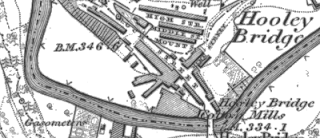
1827: Gas works established at Hooley Bridge. After expansion during the 1830s, the works included four gasometers, containing 90,000 cubic feet of gas.
1841 directory: Richard Burch, manager.
1848: Buildings present on OS map.
1867: Gas Works taked over by Heywood Local Board.
1881: Gas Works taken over by newly-formed Heywood Corporation in 1881.
1947: Large gasometer built on the other side of the river by this time.
1949: Taken over by North West Gas Board.
1968: Still marked on OS map,
Early 1970s: Demolished. A scrapyard was been on this site since that time. The large gasometer was demolished during the 1980s(?).
 |
| Heywood Gas Works, OS map, 1890. |
High Street Mill (later Excelsior Works)
Cotton spinning and manufacturing, later cabinet works
Canal Street, Hopwood
1871 directory: Schofield James and Edward, High street mill (cotton spinners).
1880 directory: Schofield J. & Co., cotton spinners, High Street Mill, Hopwood.
1880 directory: Wood Richard, Esq., J.P., cotton manufacturer, Vale Mill and John Street and High Street Mills; h. Plumpton Hall.
1891 directory: James and Edward Schofield, Hopwood; 14,000 spindles, 168/328 water twist; 401/608 pin cop.
1890: Named as High Street Mill on OS map.
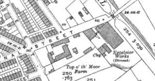
1907: Named on OS map as ‘Excelsior Works’ - ‘cabinet works’.
1928: Marked OS map as ‘cabinet works’ on.
1937: Marked on OS map as ‘disused’.
1947: Still present on OS map.
1957: Not present on OS map.
 |
| Excelsior Works, OS map, 1938. |
Highfield Mill (originally Springfield Mill)
Cotton spinning and manufacturing, later shuttle manufacturing
Springfield Street
1848: Not present on OS map.
1891: Named on OS map as Springfield Mill.
1907: Named on OS map as Highfield Mill.
1928: Marked on OS map as Cotton Spinning Mill.
1922 directory: Highfield Spinning & Manufacturing Co.
1920s: Shuttle manufacturers Pilkingtons moved from Belgrave Shuttle Works, Broadfield, to Springfield Street. Still made shuttles, also had 800 looms.
1937: Named on OS map as Belgrave Shuttle Works.
1983: Still present on OS maps.
1997: Staff reduced to nine, but the company were still selling shuttles. Relocated to Preston.
2018: Building no longer present.
 |
| Highfield Mill, OS map, 1910. |
Hooley Bridge Mills
Cotton spinning and manufacturing, originally woollen mill
Bamford Road, Hooley Bridge
1826: Fustian mills built at Hooley Bridge for Joseph Fenton.
1829 directory: Fenton, Scholfield and Co.
1840: Chimney built.
1841 directory: Fenton, Schofield & Co. cotton spinners and manufacturers, Hooley bridge.
1861: Mills ceased working due to Cotton Famine.
1891 directory: Lee and Hargreaves, Hooley Bridge; 500 looms, towels; Manchester office- 7, Rook street.
1891 directory: John Gleave and Co, Princess and Hooley Bridge Mills; 654 looms, sheetings, twills, T cloths and mexicans.
1896: Towel manufacturer William R Lees Ltd bought the mill.
1902-55: More buildings added to site.
2006: Five-storey spinning mill in northeast of the site badly damaged by fire,
2018: Buildings are still present.
 |
| Hooley Bridge Mills, OS map, 1847. |
Hope Mill
Cotton spinning
Lane End, Hopwood
1847: Not present on OS map.
1880 directory: Hodgkinson George Norris, cotton spinner, Hope Mill, Hopwood; h. Hope cottage.
1890: Marked on OS map as Hope Mill.
1891 directory: George Norris Hodgkinson, 14,400 spindles.
1928: Marked as Cotton Mill on OS map.
1937: Marked as ‘disused’ on OS map.
1947: Still present on OS map.
1957: Not present on OS map.
 |
| Hope Mill, OS map, 1928. |
Hopwood/Hebers Workhouse
Hebers Lane, Hebers, Middleton
A workhouse was a 19th-century institution where those unable to support themselves were offered accommodation and employment.It is likely that the Hopwood Workhouse was in fact same institution as the Hebers Workhouse, from where the children would be sent to the nearby Hatter's School on Stott Lane, Hopwood. No other workhouses appear on maps of the general area. That workhouse had existed since at least 1776 and was shared by the parishes of Middleton, Birtle-cum-Bamford, and Hopwood, but after an administrational dispute in 1839 it was divided into two, with Middleton operating one side and the other parishes using the other for their paupers.
1837: Bury Poor Law Union formed, managed various workhouses including Hopwood.
1830s: An inspection of the seven workhouses around Bury found six to be acceptable, but the Hopwood Workhouse was described as ‘a filthy, miserable, discreditable place’, and it had been reported that ‘the Governor had no control over some parts of the Workhouse, and that in that part the inmates were abusive in their language and turbulent in their dispositions’.
1848: Marked on OS map as Workhouse.
1851: New workhouse opened at Oldham, replacing several smaller ones, including the one at Hebers.
1890: Building present on OS map.
The buildings are present on all OS maps until the 1940s.
 |
| Hopwood/Hebers Workhouse, OS map, 1847. |
References
- Barrett’s 1880 Directory of Bury, Heywood, Ramsbottom, Radcliffe and Pilkington.
- Commercial Directory and Shippers Guide, 1875.
- Hannah Haynes, Heywood, Chalford Publishing, 1997.
- Heap’s 1850 Directory of Bury
- Heywood Advertiser (various dates).
- Heywood Living Memories.
- John Hudson, Heywood in Old Photographs, Sutton Publishing 1994.
- Ordnance Survey maps (various).
- Pigot and Co.’s national commercial directory for 1828-29.
- Pigot and Co.’s Royal National and Commercial Directory of August 1841.
- AV Sandiford and TE Ashworth, The Forgotten Valley, Bury and District Local History Society, 1981.
- Slater’s 1888 Directory of Bury, Heywood, Radcliffe and Ramsbottom.
- Worrall’s 1871 Directory of Bury, Bolton and district.
- Worrall's Cotton Spinners & Manufacturers Directory for Lancashire 1891.
- Worrall’s 1891 Directory of Bury, Bolton and district.


Comments